Ancient Egyptian Geography
The geography of Ancient Egypt was an interesting concept from the perspective of the ancient Egyptians themselves. They believed their country was divided into two distinct geographical sections, the black land (the fertile banks of the river Nile) and the red land (the barren desert that covered the rest of the country).
Location
The location of ancient Egypt was in North-Eastern Africa, having formed and flourished along the lower portion of the Nile River. It made up most of what is now the modern Arab Republic of Egypt.
Ancient Egypt had four main divisions of its land, the first two being the Upper and Lower Egypt. It may appear odd that the Upper Egypt actually referred to lands to the south, yet this distinction was based on the flow of the Nile. Upper Egypt was little more than a river valley, only about two miles wide at its narrowest and 12 at its widest. Tall cliffs surrounded it on either side. Lower Egypt was the wide delta sitting where the modern city of Cairo is now.
The last two divisions were between red and black land, as previously mentioned. The western desert contained the occasional oasis, but the eastern desert was mostly barren and hostile, save for mines and quarries.
Climate In Ancient Egypt
The climate of ancient Egypt was much the same as it is today; a hot, dry desert climate with very little rainfall. Coastal areas would benefit from winds coming off the Mediterranean Sea, but in the interior, these winds were hardly felt and temperature was high, especially in the summer.
Between March and May, a hot, dry wind called the khamasin blows through the desert. This wind causes humidity to drop and temperatures to soar over 110 degrees Fahrenheit. Rain and clouds are more prevalent near Alexandria, which is influenced again by the Mediterranean Sea. The mountainous region of Sinai has the coolest temperatures during the night, due to its elevation. Winter temperatures can drop as low as three degrees Fahrenheit during the night in some towns.
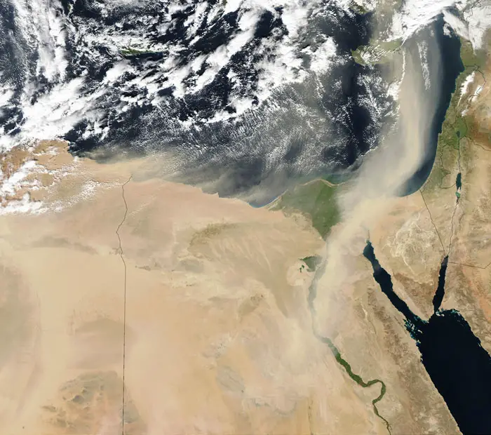
View of Saharan dust blowing over Egypt and towards the Middle East
Geology
A huge portion of ancient remains are various types of stone, from which a lot can be gleaned about the geology of ancient Egypt. A variety of sedimentary stones were used, including limestone, rock gypsum, sandstone, chert and travertine.
Quarries to find limestone were mostly built in the hills overlooking the Nile River valley. Travertine and chert were also found in these quarries, while additional quarries for limestone were built near Alexandria and the area where the Nile poured into the Mediterranean. Rock gypsum was found near the Red Sea as well as in the Western desert areas.
Igneous rock, such as granite, quartz diorite and andesite, came mostly from the deserts, with the exception of the famous Aswan granite quarry on the Nile. The ancient Egyptians had access to a variety of gemstones for jewelry making as well. Some of these stones included emerald, beryl, garnet, peridot, turquoise and a wide variety of quartz such as agate and amethyst. These precious gemstones were found in Sinai, the deserts and an island in the Red Sea.
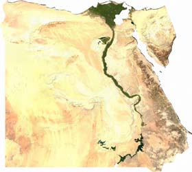
Satellite image of Egypt
The Deserts of Ancient Egypt
The deserts of ancient Egypt were the Red Lands, situated on both sides of the Nile.
The Western Desert was actually part of the Libyan Desert and covered 262,000 square miles. Its geography largely consisted of valleys, sand dunes and some mountainous areas. This desert also contained oases, five of which are still known today.
The Eastern Desert extended out to the Red Sea. It is part of what is known as the Arabian Desert today. This desert was arid and barren, but the ancient Egyptians used it extensively to mine various stones. The geography of this desert consisted of more mountains and rocky areas than sand dunes.
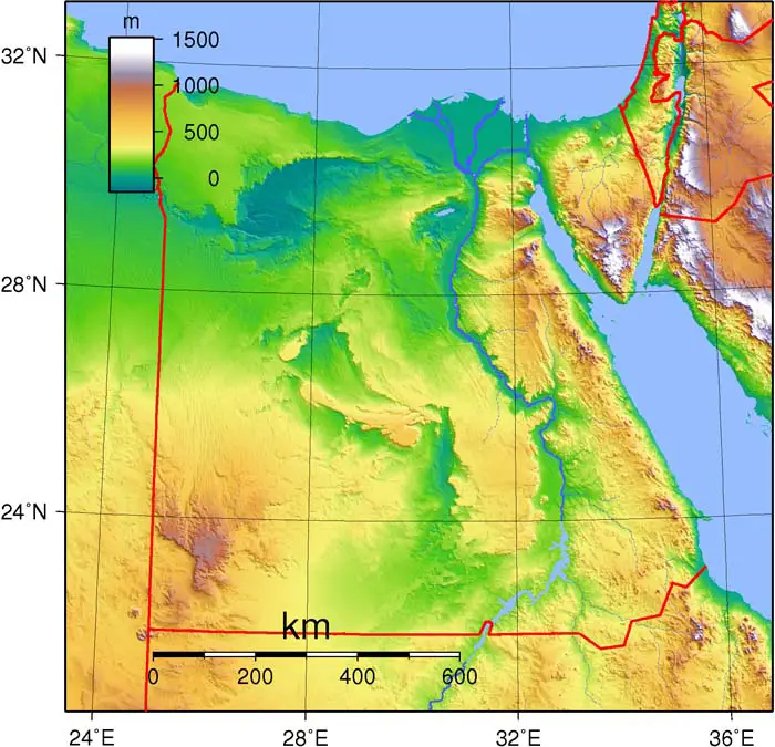
Topography of Egypt
The River Nile
The well-known summation of Egypt's existence as the "gift of the Nile" came from the Greek philosopher Herodotus. The philosopher rightly observed that everything that caused the Egyptian civilization to exist and flourish came from the Nile. Very little rain fell in ancient Egypt, certainly not much more than falls in the present, and so drinking water, washing water, water for crops and animals, all of it came from the Nile.
The headwaters of this great river lie deep in Africa and every spring, snowmelt from the Ethiopian highlands poured down into the river, causing it to slowly rise. The Nile floodwaters were extremely predictable, overflowing sometime in late July, then receding in November, wildly contrasting to the floods in Mesopotamia, which were unpredictable and extremely destructive when they did happen. Ancient Egypt flourished as the garden of the ancient world.
Click here to learn more about The Nile River
Quick Facts About The Geography Of Ancient Egypt
- The Nile River was the center of ancient Egypt.
- The predictable and gentle flooding schedule of the Nile helped Egypt flourish for nearly 3,000 years.
- Ancient Egyptians referred to its deserts as the Red Lands and they were considered barren and hostile.
- The climate of ancient Egypt was much like today: hot and arid.
- The flooding of the Nile was caused by snowmelt far to the south where the Nile begins.
- The Greek philosopher Herodotus called Egypt "the gift of the Nile."
- The ancient Egyptians divided their calendar according to the Nile, with the first season being inundation, the second was for growing, the third for harvesting.
- Stones of all types were found in the deserts and mountains of ancient Egypt.
- The Nile River served as the main transportation hub of ancient Egypt.